REVIEW · SAN FRANCISCO
San Francisco 1-Hour Seaplane Tour
Book on Viator →Operated by Seaplane Adventures · Bookable on Viator
San Francisco looks different from water. This 1-hour seaplane flight gives you big-window views over the Golden Gate and the Northern California coast, with an up-close feel for Marin and the Bay Area skyline. You get an aerial overview that’s hard to match from land, and the pilot’s commentary helps you connect the dots fast.
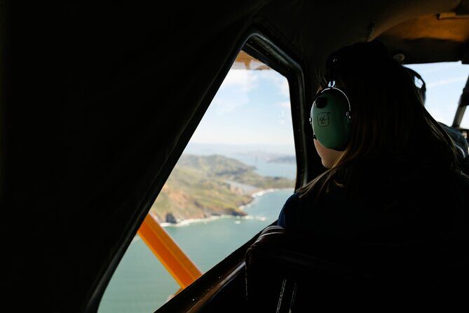
What I like most is the sightlines. The high-wing design and large windows mean you’re not constantly fighting for a clean angle, especially when you’re watching the coastline curve and the city landmarks slide into view.
One thing to think about: flight plans can shift with weather, so you’re booking an experience that’s scenic-first, schedule-second. If you’re the kind of traveler who hates uncertainty, keep that in mind.
In This Review
- Key things to know before you go
- The View Setup: big windows, high wings, and real angles
- Sausalito and Fisherman’s Wharf: how the shuttle really helps
- Richardson Bay takeoff: when the day clicks into vacation mode
- Marin coast and Point Reyes: the route you’ll remember
- Muir Woods and Muir Beach: forest and coast from above
- Marin Headlands and the Golden Gate setup
- Over the city: Crissy Field, Coit Tower, Oracle Park, and Pier 39
- The Bay loop: Alcatraz, Angel Island, and that aerial scale
- Smooth touchdown in Sausalito: what to do next
- Price and value: is $426 per person worth it?
- Should you book this seaplane tour?
- FAQ
- How long is the seaplane flight?
- Where does the flight take off and land?
- Is round-trip shuttle transport from Fisherman’s Wharf included?
- What are some of the main places you’ll see from the air?
- How many passengers are on the seaplane?
- Can the flight route change?
- What’s included in the ticket price?
- What’s the cancellation policy if plans change?
Key things to know before you go
- 60-minute flight time in a small 6-passenger seaplane means more window time, less waiting around.
- Round-trip shuttle (optional) can move you between Fisherman’s Wharf and Sausalito if you request it.
- Richardson Bay water takeoff and landing is part of the fun, not just a mode of transport.
- Point Reyes and the Marin coast are the main event, with iconic coastline scenery from above.
- Aerial Bay highlights include the Golden Gate, Alcatraz, Angel Island, and more city landmarks.
- Pilot-led landmark spotting helps you understand what you’re seeing while you’re up in the air.
The View Setup: big windows, high wings, and real angles
If you’ve ever sat on a tour bus with the best views blocked by the people in front, you’ll appreciate how this kind of seaplane ride is built for sightseeing. The plane’s layout is designed so you can look out without needing to lean at odd angles. That matters most when you’re tracking long coastline stretches—where the view changes every few minutes.
The seat count is also the quiet secret sauce. With a maximum of 6 passengers, you don’t feel like you’re sharing a sightseeing slideshow with 40 other people. There’s room to actually look, point, and then re-look as the pilot turns the plane to bring the next landmark into view.
And because it’s a short flight, you don’t have to guess whether the best parts are near the start or near the end. You’re in the sky long enough to get a full sweep, but short enough that you won’t be mentally checked out halfway through.
You can also read our reviews of more tours and experiences in San Francisco

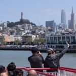
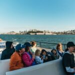
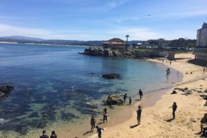
Sausalito and Fisherman’s Wharf: how the shuttle really helps
This is a tour that’s centered around the water in and around Sausalito, not a pick-up at your hotel. If you’re staying in San Francisco and don’t want to puzzle out local transport, the round-trip shuttle from Fisherman’s Wharf is a practical add-on. You just need to flag it in your special requirements when booking.
Think of it like this: you’re trading some flexibility for a smoother day. Instead of coordinating rides, navigating traffic, and timing your arrival to meet the seaplane schedule, you’re handed a simple plan: get yourself to Fisherman’s Wharf, then let the shuttle handle the jump to Sausalito.
One more practical note: your day is built around the start time (the activity starts at 1:00 pm) and the fact that weather can influence what the pilot prioritizes. So if you’re planning a tight dinner reservation right after, it’s smarter to build in some buffer rather than treat the timeline like a metronome.
Richardson Bay takeoff: when the day clicks into vacation mode
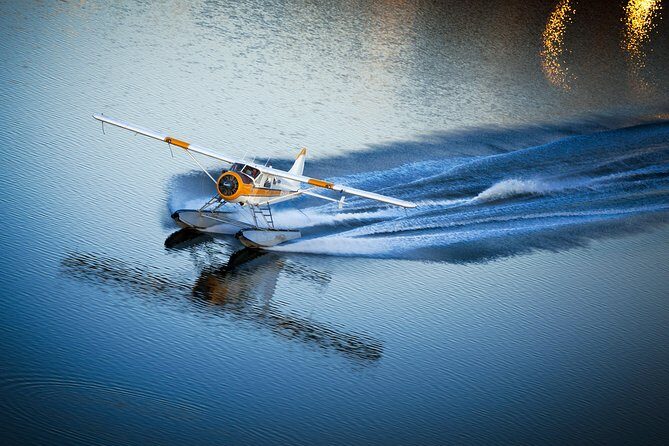
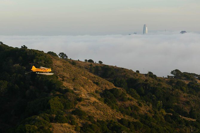
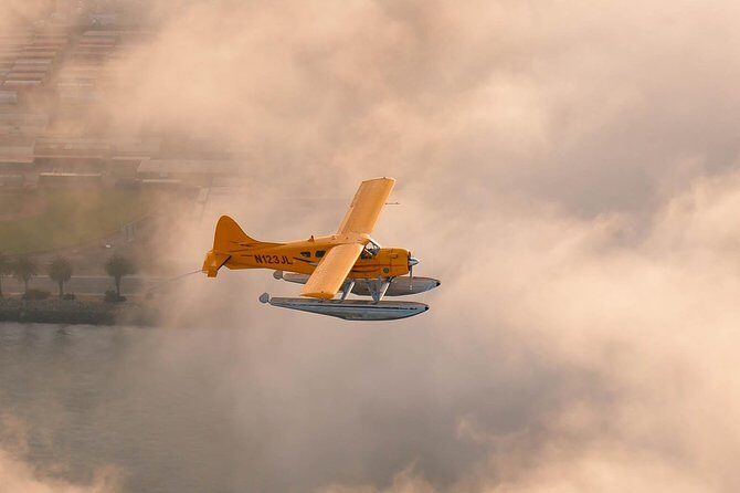
The experience starts right where it should—on the water. After you arrive in Sausalito, you board your small amphibious seaplane and take off from the bay with an experienced pilot. The first minutes are often the most exciting because the Bay Area texture becomes obvious: the water, the hills, the bridges, the way fog sometimes sits like a blanket at ground level.
Then the plane climbs and the views start to sharpen. You’ll be watching coastlines, small coves, and the shapes of peninsulas in a way that’s tough to reproduce from any overlook. And because it’s a water operation, you’ll also get a sense of scale you don’t always notice on land—like how wide the Bay really is and how quickly the shoreline changes character.
The takeoff and landing are smooth enough to focus on the views, but still, remember you’re in an aircraft, not a boat. If you’re sensitive to motion, it’s worth going in with a calm mindset and giving yourself permission to just enjoy the ride rather than analyze it.
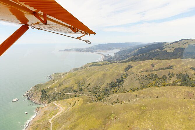
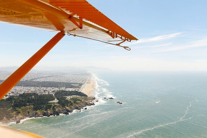
Marin coast and Point Reyes: the route you’ll remember
The heart of this flight is Marin and the Northern California coastline. This is where the scenery turns from city-and-bridge iconic to wild-and-open. You’ll look down at Tomales Bay and Point Reyes National Seashore, which is known for that mix of dramatic coastline, quiet beaches, and farmland shapes that look almost sculpted from above.
One of the itinerary highlights is the rare tidefall, where water flows into the ocean in a way that looks unusual from the air. It’s the sort of natural feature that’s hard to spot from a road or trail unless you already know exactly where to stand. Up above, it becomes a clear visual moment—water meeting sea in a pattern you can actually track.
You’ll also get a pass around the Point Reyes Lighthouse. From the sky, the area reads like a map: the headland, the ocean line, and the way the lighthouse anchors a view that would otherwise be just coastline.
Keep your eyes open for whales in the water. The tour description doesn’t promise sightings, but it does frame whale-spotting as a real possibility along the route. If you spot spouts or movement, the whole flight feels instantly more alive.
Muir Woods and Muir Beach: forest and coast from above
Not every seaplane route gives you a combination like this. You’ll fly near Muir Woods and out toward Muir Beach, and those two areas complement each other in a way you can feel from the window.
From the air, a forest isn’t just green. It’s layered. You can see depth in the canopy, the way gullies and ridgelines create natural patterns, and how roads thread through the terrain. That’s the kind of view that helps you understand why this part of California feels so different from the more open coastal stretches you’ll see nearby.
Then you shift toward the coast side, where the scene becomes more open and the shoreline shapes become the focus. Muir Beach helps you connect the dots between inland hills and ocean-facing cliffs, which is exactly what you want when you’re trying to get a true sense of the Bay Area’s geography instead of just collecting landmarks.
If you’re doing this as a first-time Bay Area visitor, these stops do a lot of heavy lifting. They make the region feel real and three-dimensional.


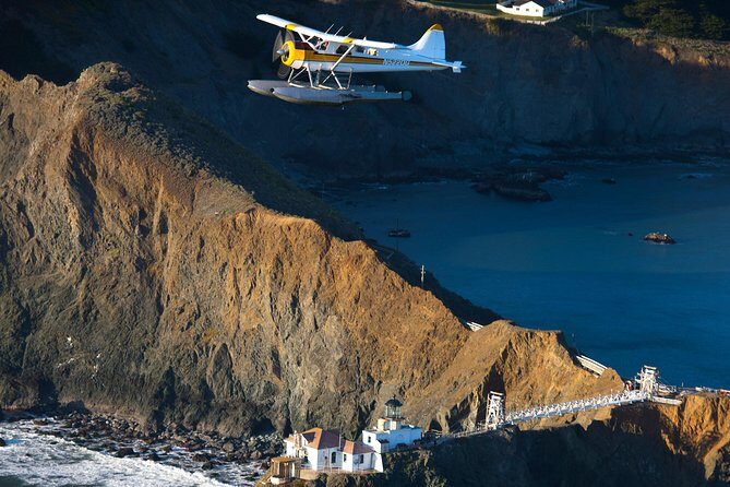
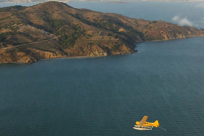
Marin Headlands and the Golden Gate setup
As the flight moves toward the southern edge of Marin, you’ll pass over the Marin Headlands, which is a big “I get it now” moment for a lot of visitors. The peninsula shape becomes clear from above, and you start seeing how the Golden Gate isn’t just a bridge—it’s a specific gap between water bodies, surrounded by land that rises quickly.
Then the route tightens around the most famous visual symbol in the Bay Area: the Golden Gate Bridge. From a seaplane, you’re not just looking at the bridge as a standalone icon. You’re seeing it in context—ocean meeting Bay, currents implied by the water colors, and the bridge placed exactly where the geography demands it.
One of the best parts is how the flight naturally layers your sightseeing. First you get coastline and headlands. Then you get the bridge. After that, the city skyline starts to come into view, so you’re not switching contexts abruptly—you’re moving through a connected story of land and water.
Over the city: Crissy Field, Coit Tower, Oracle Park, and Pier 39
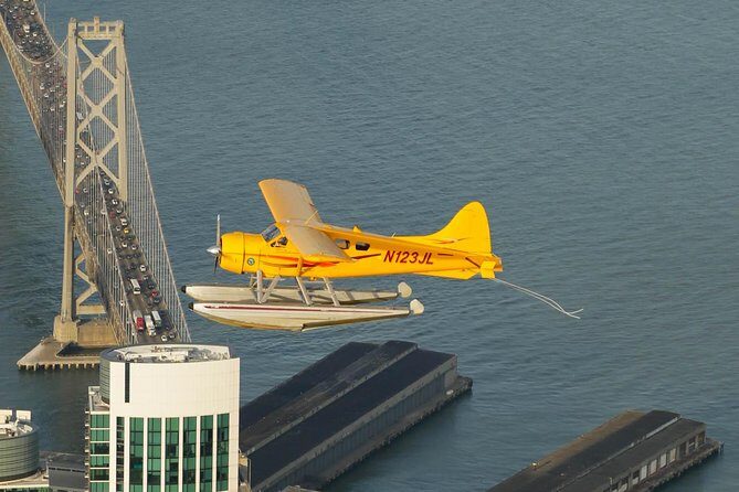
Once you’re flying past the city, the views get crisp and busy in the best way. The tour route includes a look at Crissy Field, Coit Tower, and Oracle Park. Seeing these from above helps you understand the “why” behind their locations—why some spots look close to water, why others sit tucked behind hills, and how the Bay wraps the city.
Coit Tower is located on Telegraph Hill, and the flight description notes the tower’s height (210-foot). From the sky, that detail translates into something practical: it’s easy to spot because it’s tall and positioned where it can be seen from multiple directions.
You’ll also get Pier 39 in the mix. That area is well known for its tourist draw, but from the air it reads more like a landmark anchor—an easily recognizable piece of the waterfront puzzle.
Between city passes and Bay passes, the tour gives you a quick, high-impact city orientation. It’s like getting a map drawn in real time.
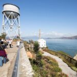
The Bay loop: Alcatraz, Angel Island, and that aerial scale
No San Francisco aerial route feels complete without Alcatraz Island. You’ll circle the Bay for an aerial look at Alcatraz and then keep going toward Angel Island, which is the largest natural island in San Francisco Bay.
From land, Alcatraz feels distant unless you’re actually on the water near it. From the air, it sits in the Bay like a solid punctuation mark. You can judge distance and shape more clearly, which makes the island’s role feel more immediate, even if you’re not focused on history during the flight.
Angel Island brings a different feeling. It’s not as instantly recognizable as Alcatraz, but from the sky the size and position of the island stand out, and you start to see how the Bay’s geography shapes everything around it.
Also on the city-and-Bay part of the flight: you’ll see the Presidio and fly along Highway 1 as the route connects the coastal side back toward the Golden Gate. That highway strip is another “context marker” that helps you build a mental model of how the region flows.
Smooth touchdown in Sausalito: what to do next
At the end, you return to Sausalito and you’ll touch down with a smooth water landing to close the loop. This matters because it’s a real ending, not just a quick circle and a dismount. You’re back where you started, and the day naturally hands you options.
You can spend time in Sausalito on your own. Or, if you arranged it, you can take the shuttle back to Fisherman’s Wharf. Either way, this is a good setup for a flexible post-flight afternoon—especially if you want to walk around and see what the Bay Area looks like now that you’ve already studied it from the sky.
Just remember: because the flight route can vary with weather, your “exact highlight order” can shift. But the core promise stays the same: Bay, bridges, coastline, and the key landmarks people come for.
Price and value: is $426 per person worth it?
At $426 per person, this isn’t a budget activity. The value comes from three places.
First, it’s time-efficient. You’re getting roughly a 60-minute flight, and the sightseeing density is high. You cover a lot of territory in a short period—Golden Gate, Alcatraz, Angel Island, Marin coast, and key Bay Area city landmarks.
Second, it’s small-scale. With a maximum of 6 passengers, you get less crowding and more focused viewing. That changes the whole vibe versus big-group tours where the best views get shared in a scramble.
Third, the ride itself is distinctive. Taking off and landing on the water isn’t a gimmick here—it’s part of the experience that makes the scenery feel closer and more real.
Who should seriously consider this? If you want a first-week-in-San-Francisco “big picture” view, or if you’re the type who loves geography and wants to see how land and water connect, you’ll likely feel satisfied. If you mostly want museums, long walks, or a deep schedule of stops, you might prefer something slower and cheaper.
Should you book this seaplane tour?
I’d book it if you want a high-impact Bay Area perspective with minimal logistics fuss. The optional shuttle from Fisherman’s Wharf helps. The small passenger count helps. And the route hits the big visual anchors—Golden Gate, Alcatraz, Angel Island—while also delivering real nature scenery in Marin and Point Reyes.
I’d hesitate if your schedule is extremely tight or you dislike weather-related changes. Since the flight route may vary, you’re buying the experience and the views, not a rigid checklist.
If you’re celebrating something or simply want one standout day that feels like it belongs in a travel photo album, this is one of the cleanest ways to do it.
FAQ
How long is the seaplane flight?
The flight portion is scheduled for about 60 minutes (the total tour duration is listed as approximately 1 hour).
Where does the flight take off and land?
The seaplane takes off from and lands back at Sausalito Bay (with a water takeoff and a water landing).
Is round-trip shuttle transport from Fisherman’s Wharf included?
Shuttle is included only if you request it. It’s listed as round-trip transport from Fisherman’s Wharf to Sausalito and back.
What are some of the main places you’ll see from the air?
The tour highlights include Golden Gate Bridge, Tomales Bay, Point Reyes National Seashore (including the lighthouse area), Muir Woods, Alcatraz Island, and Angel Island, plus Bay Area city landmarks like Crissy Field, Coit Tower, Oracle Park, Pier 39, and Oracle Park area sights.
How many passengers are on the seaplane?
The seaplane seats a maximum of 6 passengers.
Can the flight route change?
Yes. The flight route may vary due to weather or other factors.
What’s included in the ticket price?
Included items are the professional pilot and the 60-minute flight. If you request it, round-trip shuttle transport from Fisherman’s Wharf is also included.
What’s the cancellation policy if plans change?
You can cancel for a full refund if you cancel at least 24 hours before the start time. If you cancel within 24 hours of the start time, the amount paid is not refunded.