REVIEW · SAN FRANCISCO
Sausalito: Norcal Coastal Tour
Book on GetYourGuide →Operated by Seaplane Adventures / Aero Adventures · Bookable on GetYourGuide
Seeing the Golden Gate from above is the point. This Sausalito-starting, 60-minute NorCal coastal flight stacks big-view moments like Point Reyes and the San Francisco skyline in one outing that feels efficient. I especially like the bird’s-eye way you can follow the coast as it curves toward Highway 1, and I also like that the pilot narrates what you’re looking at, so the views aren’t just pretty blur. One thing to consider: weather and federal airspace rules can change routes, and the activity is listed as non-refundable.
What makes it practical is the format: a small group capped at 6, a pilot-guided flight, and that classic seaplane experience of taking off and landing on water in Sausalito’s bayside setting. You can choose English for sure, while French and Dutch guides are only possible depending on pilot availability. Plan for an all-in day feel, since there’s van time around the flight, even though the flying itself is 60 minutes.
In This Review
- Key Highlights You’ll Feel in Your Camera Roll
- Soaring From Sausalito’s Richardson Bay Water Start
- The Marin Peninsula and Tomales Bay Stretch—Coastline in One View
- Point Reyes National Seashore and Wildlife Spotting From the Air
- Point Reyes Lighthouse: A Landmark With Real Scale
- Highway 1 From Above and the Northern California Coastline Run
- Golden Gate Bridge Overhead—The Icon, Reframed
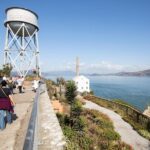
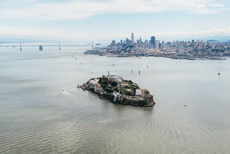
- Crissy Field, Downtown San Francisco, AT&T Park, and Alcatraz Views
- Angel Island Pass and the Return to Sausalito
- Price, Duration, and Why This $399 Flight Can Still Be Worth It
- Group Size, Pilot Narration, and What the Small Details Mean
- Who Should Book This Tour (And Who Might Want to Skip It)
- Should You Book Sausalito: NorCal Coastal Tour?
- FAQ
- Where is the meeting point?
- How long is the flight?
- How many people are in the group?
- Is there a weight limit?
- Can I arrange a shuttle from Fisherman’s Wharf?
- What if the flight is canceled due to weather?
Key Highlights You’ll Feel in Your Camera Roll

- Sea-plane start in Sausalito (Richardson Bay), across the Golden Gate, with water takeoff and landing
- Marin County and Tomales Bay views, with the route tracing the shoreline above Highway 1
- Point Reyes National Seashore from above, including a look for porpoise and whales
- Point Reyes Lighthouse from the sky, plus wide-open coastline angles you can’t get from land
- San Francisco skyline overflights, including Crissy Field, downtown, AT&T Park, and Alcatraz
- Golden Gate Bridge from overhead, before you return toward Sausalito via Angel Island
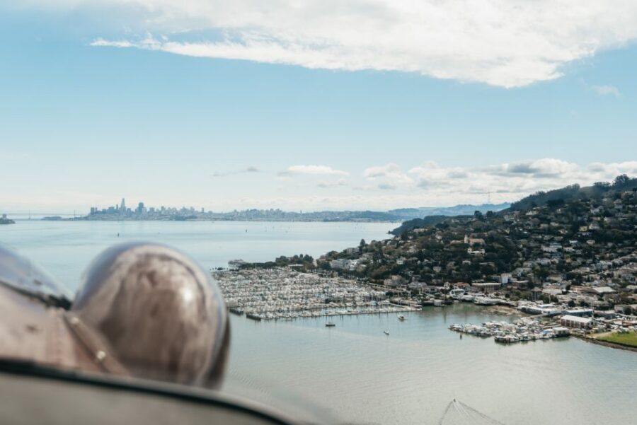
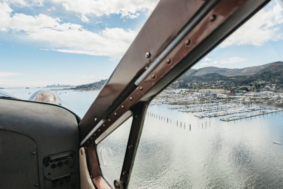
Soaring From Sausalito’s Richardson Bay Water Start
This tour begins in Sausalito, just across the Golden Gate Bridge, and it does the thing you came for right away: it’s a seaplane flight. Taking off from the water changes the vibe. It feels less like a fixed-seat sightseeing bus and more like you’re stepping into a moving viewpoint.
The pacing is also built for short attention spans. You’re not spending hours driving to viewpoints and then walking to lookouts. Instead, you get a single guided loop above the coast and key city landmarks, with time in the air focused on the best angles.
One practical note: even though the flight is 60 minutes, you’ll likely spend extra time in the overall experience because there are van segments tied to the seaplane operation. If you like to keep your plans tight, just don’t book another big activity immediately before or after.
You can also read our reviews of more tours and experiences in San Francisco.


The Marin Peninsula and Tomales Bay Stretch—Coastline in One View
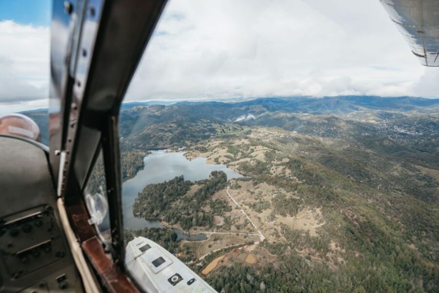
Once you’re airborne, the route moves along Marin’s coastline and out over Tomales Bay. This is the kind of stretch where the coast’s shape matters, because you can see how the land juts, bends, and opens up to the ocean. From the air, it’s easier to understand what you’d otherwise have to piece together from multiple overlooks.
There’s also a history flavor to the route. The flight follows an area where Sir Francis Drake is said to have landed over a century ago. That detail isn’t just trivia—it helps your brain “place” the coast, so you’re not just looking at random shorelines.
Expect the pilot to point out what you’re seeing as you go. That matters on coastal flights, because wind patterns, cliffs, bays, and water color can all look similar for stretches. With guided narration, you’re more likely to know what you’re looking at—and remember it afterward.
Point Reyes National Seashore and Wildlife Spotting From the Air
Point Reyes National Seashore is a major reason to book this flight, because it’s the jump from “city landmarks” into “real coast.” When you’re up above it, the boundaries of bays and headlands become obvious. It’s the kind of geography that makes photos look good even if you don’t know what setting to use.
You’ll also have a chance to look for porpoise and whales along the way. I like this because it turns the flight into more than skyline watching. Even if you don’t spot wildlife, the act of scanning from above gives you a different perspective than a roadside pull-off.
The only caution I’d give is mindset. Wildlife spotting is never guaranteed. Instead of banking on one perfect moment, think of this as a guided coastal search—an add-on to the scenery, not the entire goal.
Point Reyes Lighthouse: A Landmark With Real Scale
Rounding the area near the Point Reyes Lighthouse is a special moment because it gives you a clear target that anchors the coast. From the air, a lighthouse isn’t just a photo subject; it reads as a navigation mark—something designed for distance, not close-up views.
This is also where your sense of scale changes. Lighthouse-adjacent coast looks totally different when you can see the coastline bending away in both directions. If you’ve ever seen Highway 1 from the ground, you know how much of it is “road curves and stops.” From above, it’s easier to connect those dots.
If you’re the type who enjoys maps in your head, this section helps you build them fast. You’ll come away knowing how the coast aligns with the inland areas—no guessing required.
Highway 1 From Above and the Northern California Coastline Run
After Point Reyes, you continue along the northern California coastline above Highway 1. This is one of the most satisfying parts for people who like long views. Highway 1 can feel like a string of separate places when you drive it. From the air, it reads as a continuous ribbon, and that continuity is where the magic is.
I also like the rhythm here: coast, coastline, then the next turn that reveals a new bay or headland. The eye gets to follow the geography instead of constantly reorienting like it does on ground travel.
The potential drawback is simple: if you’re hoping for constant, city-style landmark changes every few minutes, this stretch is more about sustained scenery. It’s not a “stop-and-go” experience with dozens of tight photos. It’s a flowing coast show, and it rewards you if you enjoy that slower visual tempo.


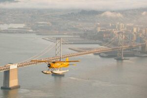
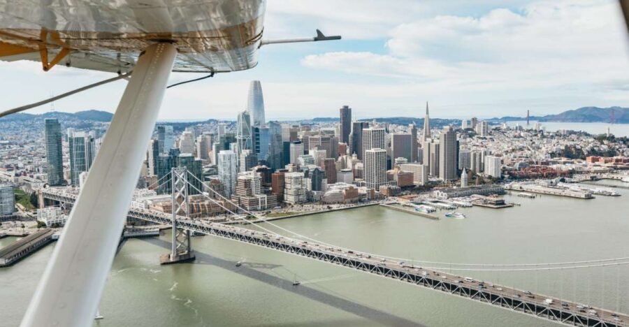
Golden Gate Bridge Overhead—The Icon, Reframed

You get to experience the Golden Gate Bridge from above, which is the payoff moment for a lot of people. From the ground, the bridge is often framed from one angle or partially blocked by terrain. From the air, the bridge sits clearly against the water and the skyline, and your brain finally gets how the span relates to the surrounding bays.
I also like that it’s not just an overflight and done. The flight route sets up the bridge as part of a larger loop: you see the coastline building toward it, then you cross above it, and later you get the wider San Francisco area again.
If you’ve done other aerial experiences before, this is still worth it because it’s not the same view as a helicopter loop that stays fixed over the city. Here, the bridge feels like a hinge between Marin and San Francisco.
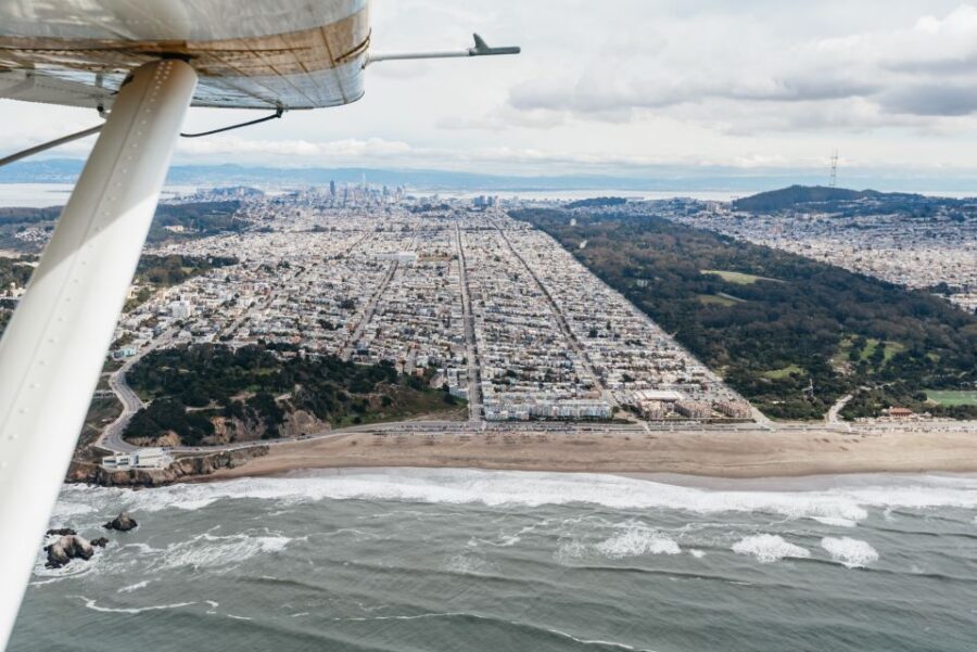
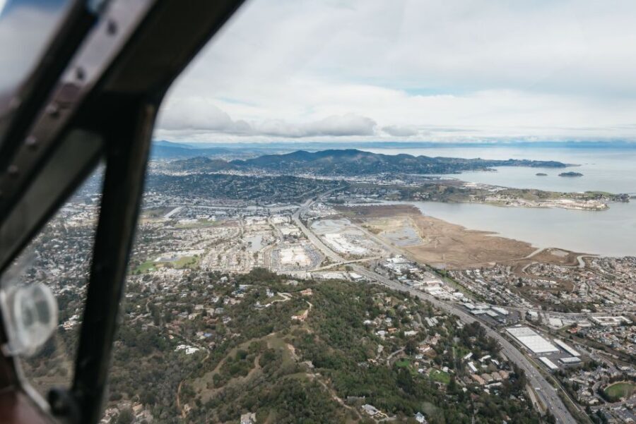
Crissy Field, Downtown San Francisco, AT&T Park, and Alcatraz Views
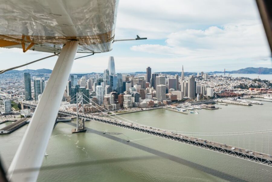
Once you’re back toward San Francisco, the skyline portion kicks in: Crissy Field, downtown San Francisco, AT&T Park (home of the San Francisco Giants), and the island prison of Alcatraz. This set of landmarks is a neat package because it spans recreation, downtown density, and a place with a very specific identity.
AT&T Park is especially useful because it gives you a “modern anchor.” Alcatraz gives you a “story anchor.” Together, they prevent the skyline from becoming generic from the air.
For me, the strongest advantage here is recognition. If you don’t know the geography of the peninsula, you can still track it by landmarks. That means you don’t have to work to interpret your view—you just get it.
One small consideration: in cities, visibility can be variable depending on weather. The flight operator may alter routes in response to conditions or federal airspace mandates, so keep your expectations flexible if your day looks hazy.
Angel Island Pass and the Return to Sausalito
Near the end, you get a pass by Angel Island, described as the immigrant gateway to the west. Even from above, it helps to have that context, because it shifts the view from scenic island to place-with-meaning. It’s a quieter moment than the city section, and that balance feels good late in the flight.
After Angel Island, you return for a smooth landing back in Sausalito’s Richardson Bay. Landing on water is part of the reason to book a seaplane rather than a typical air tour. It feels different in your senses, and it’s one of those moments where the experience becomes more than just a view.
The overall arc is satisfying: Marin coast and national seashore first, then Golden Gate and San Francisco, and finally a calmer return. That sequencing helps you remember the day as a story, not just a checklist of icons.
Price, Duration, and Why This $399 Flight Can Still Be Worth It
At $399 per person for about 60 minutes in the air, this isn’t a budget-friendly add-on. The value comes from the specific mix: a short time window that still covers a lot of top geography (Marin + Point Reyes + Golden Gate + major SF landmarks + Alcatraz + Angel Island).
If you’ve already done coastal drives or helicopter rides, this tour may feel like it’s “just another aerial loop.” But that’s where the seaplane angle matters. A water takeoff and landing changes the tone, and the pilot-led narration turns the route into an organized sight map rather than random cloud time.
Also, you’re buying concentration. A 60-minute flight doesn’t give you time for long detours or multiple separate activities. What you get instead is focused aerial sightseeing at peak vantage points. For many people, that’s the best trade: fewer logistical steps, more memorable views per hour.
Group Size, Pilot Narration, and What the Small Details Mean
This is a small group experience, limited to 6 participants. That matters for comfort and attention. It also tends to keep things more personal, especially during safety briefings and when you’re trying to hear explanations over aircraft noise.
The flight is guided by a pilot who provides live narration in English. French and Dutch guides are not guaranteed and depend on pilot availability. If you’re relying on a specific language, assume English will be the consistent option.
One reason I’d call this a “great match” for solo travelers is that the structure is clear: you meet, get briefed, fly, and return, without needing to arrange your own transport between viewpoints. You’re also likely to get more out of the experience if you’re the type who likes learning what you’re seeing in real time.
Who Should Book This Tour (And Who Might Want to Skip It)
This works best for you if:
- you want a concentrated aerial tour rather than a full day of driving and walking
- you care about coastline geography and want Highway 1 and Point Reyes angles from above
- you’d enjoy a guided flight where the pilot points things out as you go
It’s also a strong choice if you’ve already done basic city sightseeing, because this adds a “from the sea” perspective and a national seashore segment in one ticket.
Skip it if:
- you need to avoid weather uncertainty. Routes can change due to weather or federal airspace restrictions
- you’re over the listed weight limit of 260 lbs (124 kg / 18 stone) per passenger
- you’re not comfortable with a non-refundable activity status
Should You Book Sausalito: NorCal Coastal Tour?
If your goal is to see the Golden Gate area, Point Reyes, and key San Francisco landmarks without piecing together multiple days, I’d say yes. This tour’s best asset is its tight route planning: you get Marin coastline and Point Reyes up front, then the city icons, then the return all in one smooth arc.
But book with the right expectations. It’s not a long expedition. It’s a focused 60-minute seaplane experience that can shift a bit with real-world flying conditions. If you can be flexible and you’re excited by coastal geography from above, this is the kind of trip that makes sense to prioritize.
FAQ
Where is the meeting point?
You’ll meet at the seaplane base in Mill Valley, 242 Redwood Hwy, Mill Valley, CA 94941, USA.
How long is the flight?
The deluxe flight is 60 minutes. There may also be van time as part of the overall experience.
How many people are in the group?
The group is small and limited to 6 participants.
Is there a weight limit?
Yes. Each passenger must be no more than 260 lbs (124 kg / 18 stone).
Can I arrange a shuttle from Fisherman’s Wharf?
Yes, there’s an optional roundtrip shuttle from Fisherman’s Wharf in San Francisco. If you select it at checkout, you still need to confirm your pickup with the local partner at least 24 hours before your tour.
What if the flight is canceled due to weather?
If the flight is canceled due to weather, it will be fully refunded. Flights can also be canceled or routed differently due to weather or federal airspace mandates or restrictions.