REVIEW · SAN FRANCISCO
Point Reyes National Seashore Self Guided Driving Audio Tour
Book on Viator →Operated by Adventures with Action · Bookable on Viator
Point Reyes National Seashore is a drive you can do for real curiosity. This self-guided driving audio tour turns a long stretch of California coast into a sequence of easy stops, with more than 53 location-triggered stories spread over a 21+ mile route. I like that the tour is hands-free—the audio plays automatically as your phone picks up your position, so you’re not stuck fiddling with screens.
What I also like is the offline-first setup. You download once in good signal, then you can keep going even when cell service drops, using offline maps and the app’s location cues. The main drawback is practical: if you struggle with phone setup or GPS audio, the experience can feel harder than it should. One 75-year-old review said it wasn’t user-friendly, and that’s a fair warning to plan ahead and test your audio connection before you start driving.
In This Review
- Key highlights you’ll care about
- Where this Point Reyes audio drive starts and ends
- How the Action Tour Guide app works when cell service drops
- Timing your 21-mile route: 2–3 hours, plus optional walking
- Tomales Point: the 45-minute beach detour
- Drakes Estero: a marshy inlet plus a 2.5-mile trail option
- Cypress Tree Tunnel and the KPH Radio station story
- Point Reyes Beach and Drakes Beach: long sand views with wildlife payoff
- Point Reyes Beach
- Drakes Beach
- Chimney Rock overlook detour and the Historic Point Reyes Lifeboat Station
- Elephant seal and sea lion overlooks: what to look for
- Elephant Seal Overlook
- Sea Lion Overlook
- South Beach overlook and the lighthouse parking reality
- Leaning Tree and finishing at the Lighthouse Visitor Center
- Price and value: $16.99 per car for 53+ stories
- Who should book this self-guided Point Reyes drive
- Should you book this Point Reyes National Seashore self-guided audio tour?
- FAQ
- How long is the Point Reyes self-guided driving audio tour?
- How many miles and stories are included?
- Is the tour available in English?
- Is there a park pass included?
- Where does the tour start and where does it end?
- Do I need cellular service during the tour?
- Can I start and pause whenever I want?
- Do I drive my own car for the tour?
Key highlights you’ll care about

- GPS-triggered audio: the stories start as you pass each spot, so you stay in flow.
- Offline maps: no signal needed after you download the tour.
- Lifetime access: you can reuse it on any future trip without worrying about expiration.
- A true lighthouse endpoint: the route is built to end at the Lighthouse Visitor Center.
- Optional walks: add Tomales Point, Drakes Estero, or Chimney Rock when you want more feet on the ground.
- Value per car: priced per group up to 4, which can beat bus-style tours.
Where this Point Reyes audio drive starts and ends
This tour is designed as a one-way drive. You start at 1 Bear Valley Visitor Center Access Road, Point Reyes Station, CA 94956, and it ends at the Lighthouse Visitor Center, 27000 Sir Francis Drake Blvd, Inverness, CA 94937. No guide meets you at the start. You simply set up the app, park when you want, and let the audio guide your next stop.
That start-to-finish structure matters. Point Reyes can be a maze of roads and pullouts. Having a built-in end point at the lighthouse helps you avoid the common day-trip problem: you spend the whole time “figuring it out” instead of stopping for views.
You can also read our reviews of more guided tours in San Francisco


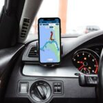
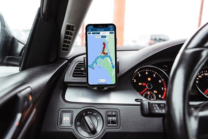
How the Action Tour Guide app works when cell service drops
The tour uses Action’s Tour Guide App (separate from the main Action site/app). After you book, you’ll get an email and text with setup instructions and a password. Then you download the tour while you’re in strong Wi-Fi or cellular coverage. Once downloaded, it’s meant to work without signal.
Here’s the practical part you should plan for:
- Start the app at the onsite location so it can grab your planned start point and direction.
- The stories play automatically based on where you are, using hands-free location cues.
- If you want audio through your car, you can connect via Bluetooth, USB, or AUX. The info also says it supports Apple CarPlay, with Android Auto coming soon.
If you’re worried about tech friction, do a quick check before you leave the lot. Make sure you can hear the audio clearly, and test that the app responds as you drive forward.
Timing your 21-mile route: 2–3 hours, plus optional walking
The route is about 2 to 3 hours for the full experience, and it’s listed as over 21 miles long with more than 53 audio stories. That timing works best if you treat it like a slow drive with short stops, not a sprint.
Two detours can add time fast:
- Tomales Point: option is a 45-minute round trip, plus time for walking around and photos.
- Drakes Estero: option is a 2.5-mile round trip trail through the marshy inlet area.
If you do both, expect the tour to stretch closer to the top end of the 2–3 hour estimate. If you keep it mostly in-car with quick overlooks, it’s easier to finish in a relaxed morning or afternoon window.
Tomales Point: the 45-minute beach detour

Tomales Point is one of those places where the road suddenly feels worth it. The audio gives you the choice: detour to the remote, windswept beaches, one of the most popular destinations on the peninsula.
The value here is twofold:
- You get big “end-of-the-world” ocean views without needing a long hike.
- You’re adding a real mini-journey, not just another pullout.
What to watch for: the tour notes the detour can take about 45 minutes round trip, and you’ll want time to walk and take photos. If you’re short on daylight, Tomales Point is the one detour I’d treat as optional until you’ve already seen the rest of the route. It’s stunning, but it’s also the easiest place to “run out of time.”
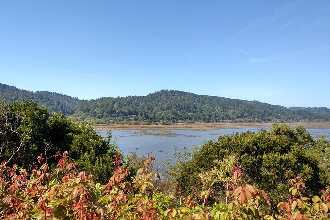
Drakes Estero: a marshy inlet plus a 2.5-mile trail option
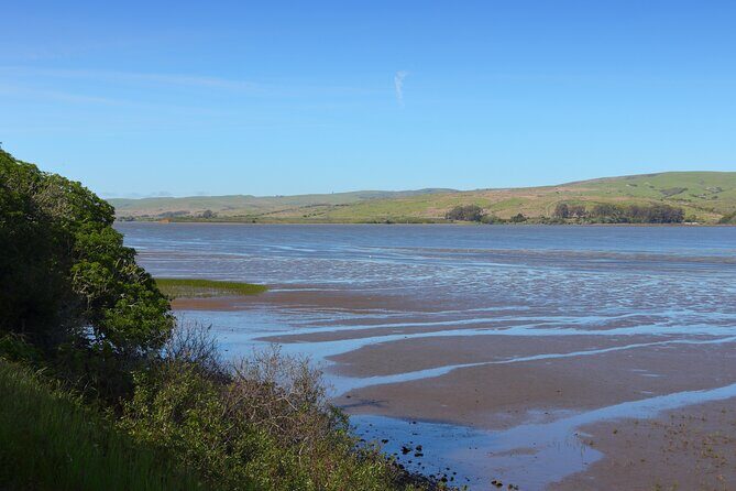
Next up is Drakes Estero. The audio even helps you decode the word: an estero is basically a marshy inlet. That’s useful because you might look at the shoreline and not realize how dramatic the terrain can be when you step into it.
If you want to stretch your legs, there’s a 2.5-mile round-trip trail. The story line sets expectations: you’ll cross coastal grasslands and get a scenic footbridge over the bay.
Your decision point is clear:
- Turn left at the Drakes Estero Trailhead if you want the walk.
- Otherwise continue driving.
The drawback to keep in mind is simple—2.5 miles adds up. This is not a quick “ten minutes and done” walk. If you’re traveling with anyone who gets tired easily, you may prefer the scenic drive portion and skip the full trail.
You can also read our reviews of more tours and experiences in San Francisco


Cypress Tree Tunnel and the KPH Radio station story
This is one of my favorite kinds of audio stops. It turns scenery into context.
You’ll see cypress trees forming a tunnel shape, and the audio explains why they’re here. In the early 1900s, Morse code radio stations were placed along the coast for communication with ships at sea. The Radio Corporation of America (RCA) selected one site here at Point Reyes, built in 1929.
Then comes the key detail: they planted rows of cypress trees leading up to the station so the infrastructure would sit more gently in the landscape.
Practical tip: pull forward enough that you can safely get out for a quick look at the cypress tunnel effect. It’s easiest to appreciate when you can stand at a point where the rows line up.
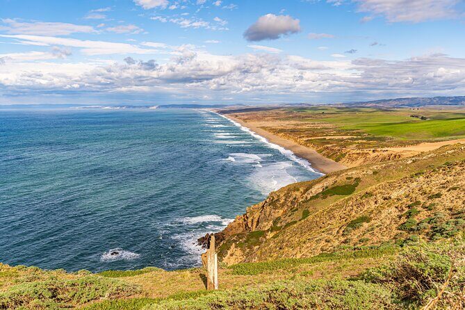
Point Reyes Beach and Drakes Beach: long sand views with wildlife payoff

The audio moves you from major coastline viewpoints to two beach stops that feel very different depending on wind and exposure.
Point Reyes Beach
You’ll learn there are 11 miles of sand and ocean views here. The audio also flags a possible seasonal highlight: gray whale sightings reported in winter and spring. So if you’re visiting in those months, don’t treat this as just a pretty beach—keep your eyes open.
Drakes Beach
Drakes Beach is popular because it faces Drakes Bay, meaning conditions often feel calmer than the ocean-facing side. The audio notes the waves can be less intense and that there are white sandstone cliffs in the background.
If you’re trying to choose a “best beach” from a limited time window, I’d think like this:
- Want maximum ocean energy and maybe whale sightings? Choose Point Reyes Beach.
- Want a more sheltered, easy beach time? Choose Drakes Beach.
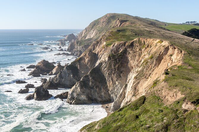
Chimney Rock overlook detour and the Historic Point Reyes Lifeboat Station
Right around the point where the coast really starts to feel serious, the tour offers another detour: Chimney Rock.
If you turn left at the fork, you get a path to:
- a lifesaving station overlook,
- an elephant seal overlook,
- and the chance to hike to Chimney Rock for ocean views.
This is a good example of why a self-guided audio tour works. You can match your effort to your mood. Need a short break? Take the overlooks. Want more legs? Go for the hike.
Then you reach the Historic Point Reyes Lifeboat Station. The story is the kind you don’t get from a quick photo stop. The station began operations in 1878, and it ran by a crew with specific roles: the station leader was called the keeper, and the staff were called surfmen.
The audio ties it to fog and survival: they patrolled beaches listening for voices and searching for wrecks. The tour notes that the first station saved people from 14 major shipwrecks over 37 years.
There’s also a standout storytelling note from the reviews: the audio includes a shipwreck story that people find memorable because it’s unusual. Even if you’re skeptical at first, this is the kind of narrative that makes the station feel alive, not just historic.
Elephant seal and sea lion overlooks: what to look for
After the lifeboat station story, the tour becomes wildlife-focused. That’s great for two reasons: it gives you a reason to slow down, and it teaches you what you’re looking at.
Elephant Seal Overlook
The audio gives you the backstory. Elephant seals were heavily exploited for blubber oil. By 1892, only about 75 seals remained along the entire Pacific coast of North America. Then protections in the 1920s allowed a slow recovery. By 1981, the first breeding pair was back at Point Reyes. Today, the audio cites roughly 200,000 northern elephant seals along the Pacific Coast of the US and Mexico.
When you visit, look for the sheer scale. The tour doesn’t just list numbers; it explains why the comeback is a big deal.
Sea Lion Overlook
Next is the sea lion overlook with a concrete detail: 54 steps down to a view that’s usually full of sea lions.
The audio also explains how to tell seals and sea lions apart:
- Check for ear flaps and folded-in back flippers.
- Sea lions use their back flippers to shuffle upright on land.
- The audio also includes breeding timing: between May and August.
If you’re there during breeding season, you may see more territorial behavior. If you’re there outside that window, the energy may be different, but the viewing can still be excellent.
South Beach overlook and the lighthouse parking reality
Now you’re approaching the part most people picture when they hear Point Reyes: the lighthouse area.
The tour emphasizes the South Beach Overlook and the fact that this is the only parking lot for the lighthouse. That single-lot detail matters on weekends, because the audio notes parking can get congested, and street parking can also be tight.
So here’s my practical approach: once you’re close, commit. Park once. Don’t play leapfrog with different lots if you can avoid it. When you’re near the lighthouse, you want fewer decisions and more looking.
The audio also positions this section as an end-of-route moment. You’ve been learning about radio stations, esteros, and wildlife, and now you get the final payoff—views focused around the point and lighthouse area.
Leaning Tree and finishing at the Lighthouse Visitor Center
After the lighthouse area, you’ll reach the Leaning Tree. The audio says it’s a cypress that leans over the path but appears not to fall.
This last stop is a nice reset. By the time you reach it, you’ve already absorbed the major themes—coastal survival stories, conservation recovery, and the way weather shapes everything here. The leaning cypress feels like a small, personal moment before you wrap.
Then you finish at the Lighthouse Visitor Center.
One small but useful note from the tour info: the Lighthouse Visitor Center opening hours are listed as 9:00 AM–5:00 PM during the date range shown, open Monday through Sunday. If you’re driving in late afternoon, aim to arrive before the last hour to avoid rushing.
Price and value: $16.99 per car for 53+ stories
At $16.99 per group (up to 4), the math can work really well if you have a small car. You’re paying for one audio license per group, not per person.
What you get for that price is more than narration. You get a structured driving route with built-in pacing:
- short stops (often around 10 minutes of story time),
- optional hikes that you control,
- and audio that gives context so stops don’t feel random.
The one catch is also clear: park passes aren’t included. If you don’t have the right pass for your visit, budget that separately so you’re not surprised at the gate or entry point.
Who should book this self-guided Point Reyes drive
This is a smart choice if you want:
- a low-stress plan with clear next stops,
- wildlife viewing paired with explanations,
- and a way to do Point Reyes without booking a guided tour.
It’s especially good for couples or small groups where everyone can share one narration stream from a car stereo. It’s also a good “first trip” option, because the route hits a strong mix: beaches, marsh, history, seals, and the lighthouse area.
Who might want to skip or at least prepare extra:
- If your group struggles with smartphones, apps, and GPS prompts, you’ll spend energy on tech instead of coast. The setup process matters—download with good signal and test audio before you start.
Should you book this Point Reyes National Seashore self-guided audio tour?
I think you should book it if you like the idea of exploring at your own speed while still having a plan. Point Reyes works best when you can stop often. This tour gives you a reason to stop, and it tells you what you’re seeing so the time feels earned.
Book it if you’re craving variety in one drive. You’ll get the beach miles, the cypress tunnel story tied to the 1929 KPH radio-era setup, and the wildlife overlooks with specific ways to identify what’s in front of you.
Skip it if your group wants a full human guide or if tech setup sounds like a headache. In that case, you’d likely get more comfort from a traditional guided experience.
FAQ
How long is the Point Reyes self-guided driving audio tour?
It takes about 2 to 3 hours to complete.
How many miles and stories are included?
The tour route is over 21 miles long and includes more than 53 audio stories.
Is the tour available in English?
Yes. The tour is offered in English.
Is there a park pass included?
No. Park passes are not included.
Where does the tour start and where does it end?
It starts at 1 Bear Valley Visitor Center Access Road, Point Reyes Station, CA 94956 and ends at the Lighthouse Visitor Center, 27000 Sir Francis Drake Blvd, Inverness, CA 94937.
Do I need cellular service during the tour?
You should download the tour while you’re in strong Wi-Fi/cellular first. After that, it’s designed to work offline.
Can I start and pause whenever I want?
Yes. You can start anytime and pause anywhere, as you explore at your own pace.
Do I drive my own car for the tour?
Yes. This is a self-guided driving tour, and the app plays audio automatically based on your location.