REVIEW · SAN FRANCISCO
Airplane Elite San Francisco Flight Tour
Book on Viator →Operated by Fly San Francisco Tours · Bookable on Viator
Two bridges, one smooth hour in the sky.
This private scenic flight is a fast way to see San Francisco from above, with a pilot guiding you over the places you usually only spot from the ground. You’ll fly from Hayward through Oakland and out toward the Bay Bridge before circling back for classic views of the Golden Gate and the city’s coastline.
What I love most is the way the pilot turns the route into a running lesson. Pilot commentary can help you connect what you’re seeing—ports, bridges, neighborhoods, and coastline—with how the Bay Area grew and functions. And the second big win is the photo-friendly angles: from the air, you can frame landmarks next to water and roadways in a single shot.
One thing to consider: this is a small aircraft experience. If you’re nervous about flying or you’re tall and worry about snug seating, you may want to mentally prepare for a tighter space than a large commercial plane.
In This Review
- Quick take: what you’ll get most days
- A private flight that starts fast (and feels personal)
- Oakland and the Bay Bridge: the route’s first big payoff
- Treasure Island and the Bay water views: where the Bay looks staged
- Golden Gate, Crissy Field, and a shoreline you can almost read
- Embarcadero to Mission District: city landmarks in one sweep
- Twin Peaks to SFO, then San Mateo: how the Bay looks on the return
- Price and value: what $339 buys in the sky
- Practical tips that make this tour better
- Should you book this flight tour?
- FAQ
- How long is the airplane flight tour?
- What does it cost per person?
- Is this tour private?
- Where does the flight start and end?
- What landmarks will we fly over?
- Is the tour offered in English?
- What happens if the weather is bad, and can kids or service animals participate?
Quick take: what you’ll get most days
- Private flight with only your group (not a big shared bus in the sky)
- Route packed with landmarks: Oakland, Bay Bridge, Treasure Island, Alcatraz area, Golden Gate, Crissy Field, and more
- Pilot-led stories that turn views into context, not just sightseeing
- Photo opportunities you can’t easily recreate on land (bridges and shoreline look different from above)
- Weather matters: good conditions are required, and delays or reroutes can happen if airspace is restricted
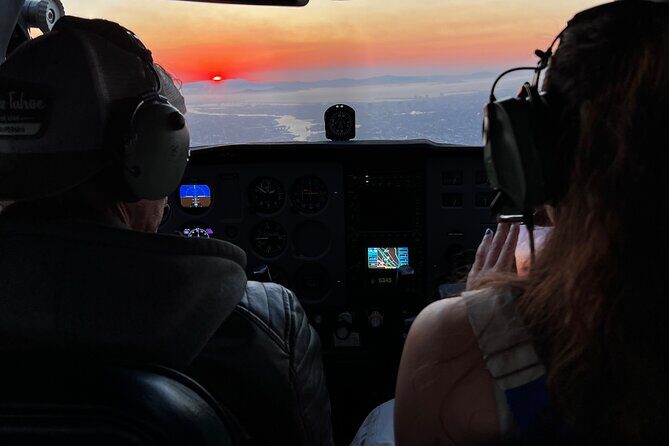
A private flight that starts fast (and feels personal)
The whole point here is pace and access. You’re not spending your day commuting between viewpoints or waiting for the next departure. You’re meeting in Hayward and then getting up for an experience that clocks in around 50 minutes to 1 hour—long enough to see a lot, short enough to fit into a busy vacation plan.
Because it’s private, the vibe can shift. You can ask questions. You can point at something you didn’t expect. And if you’re celebrating—birthday, date, or a gift—this style of outing tends to land well. Many people also mention the flight feels smooth, and the staff/pilot side of the operation comes across as friendly and reassuring.
You should also know what the experience is set up to do: this is built for viewing and photography, not a long, multi-part excursion. If you like fast, focused sightseeing with a clear route, you’ll likely appreciate that.
You can also read our reviews of more tours and experiences in San Francisco.


Oakland and the Bay Bridge: the route’s first big payoff
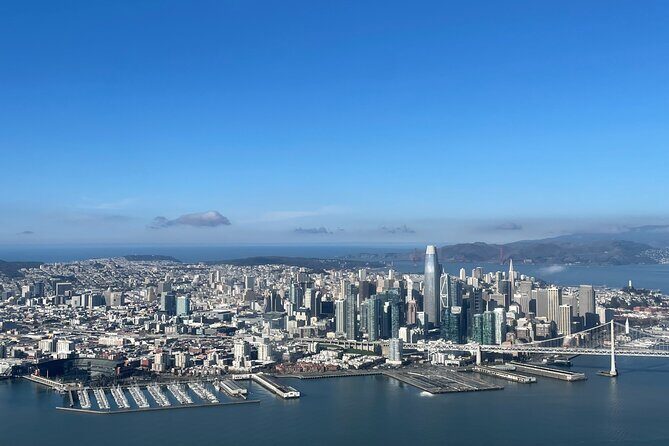
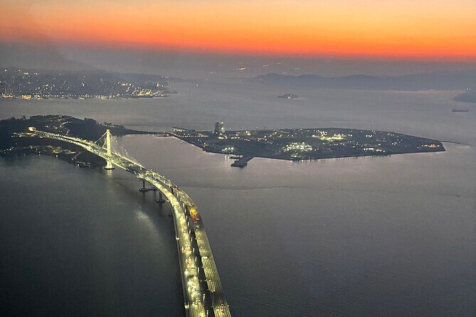
The tour begins with Oakland views and a quick push toward the Bay Bridge area. The skyline is one of those things that looks impressive from afar, but from the air it snaps into sharper focus. You see how the city hugs the water, where major roads feed into the bridge, and how the Bay acts like a divider and a connector at the same time.
Then comes the Bay Bridge itself—usually the moment people start smiling without trying. From above, you can appreciate the bridge’s scale and the surrounding geometry: water channels, the shoreline’s curves, and how traffic routes relate to the neighborhoods below. It also sets up what follows, because it visually places the rest of the Bay Area like a map you can fly through.
A small practical note: if you’re chasing specific photo angles, this is a good early moment to get your camera ready. A lot of the best compositions come when you’re ready before the plane lines up.
Treasure Island and the Bay water views: where the Bay looks staged
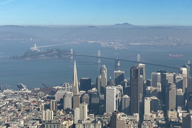
Once you’re moving off the Bay Bridge, you’ll pass over Treasure Island as the flight continues toward the City. It’s a short stretch, but it’s a memorable one. A man-made island can look like a simple shape from the shoreline. From the air, it becomes part of the larger Bay layout—water, bridge approaches, and the city’s backdrop all in one frame.
Right after that, you get more Bay water context. You’ll fly nearby the old Alcatraz Prison area, and you’ll also see how the Bay’s water color and wind patterns can change the look of the coastline. That matters for photos. Clear days can look crisp and bright; hazy or softer light can make the Bay feel more cinematic.
One useful way to think about this portion: it’s where the tour stops being only about famous landmarks and becomes about how the Bay works spatially. Bridges aren’t just bridges here. They’re moving you between different layers of geography.
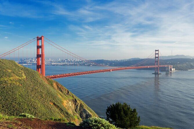
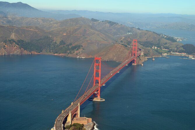
Golden Gate, Crissy Field, and a shoreline you can almost read
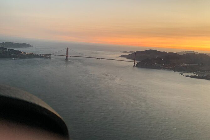
If you’ve ever looked at the Golden Gate Bridge and thought it looked best in photos, this is where you confirm it. You’ll get a pass over the Golden Gate Bridge, and it’s the kind of view that makes the whole Bay Area feel legible: bridge span, shoreline, and the city’s edges all line up in your mind.
After that, the route continues along the waterfront zone, including Crissy Field. This is one of those areas that can seem ordinary from the ground. From above, you can see beach shapes, park edges, and how the coastline bends around viewpoints. It’s also a good stretch for photos because the scene isn’t just one landmark. It’s the whole shoreline story.
If you’re sensitive to motion or tight seating, this is also where nerves can show up for some people. The flight is described by many guests as smooth and safe, but you still might feel the reality of a small aircraft. If you’re worried, keep your body relaxed, hold your camera/grip firmly, and let the pilot do the smooth flying.
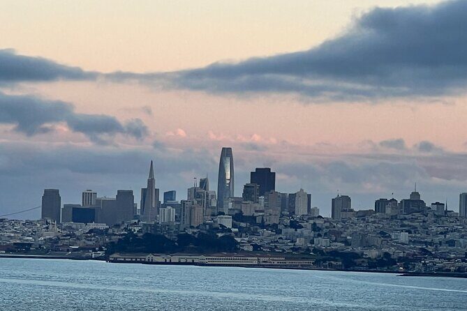
Embarcadero to Mission District: city landmarks in one sweep
Next, you’ll fly along parts of the Embarcadero corridor. From the air, you can trace how the City’s waterfront connects with major neighborhoods and famous streets. You’ll pass over areas that include things like Lombard Street, Coit Tower, Pier 39, Union Square, and the Painted Ladies vicinity—then you keep going toward the Mission District.
The Mission District portion is where the City’s density really shows. From above, you see how the skyline layers with neighborhood blocks and where the terrain rises. It’s a helpful perspective if you’ve only done viewpoint stops on foot. It helps you understand why certain views feel steep, and why roads and neighborhoods look the way they do.
One more benefit: the air route lets you connect landmarks you usually see separately. On the ground, you jump from one area to another with long walks or rides. In the sky, the flight stitches them together into one continuous look.


Twin Peaks to SFO, then San Mateo: how the Bay looks on the return
As the flight continues south, you’ll pass Twin Peaks. That’s a big one for context. Twin Peaks is often treated like a single lookout. From the air, it becomes part of the Bay Area’s vertical geography—an obvious reminder that this isn’t a flat city situation.
Then you’ll fly by San Francisco International Airport (SFO). You get an aerial feel for scale: runways, approach patterns, and the sense of constant movement around the Bay. Even if you’re not a flight person, the contrast is striking—nature and neighborhoods on one side, major aviation infrastructure on the other.
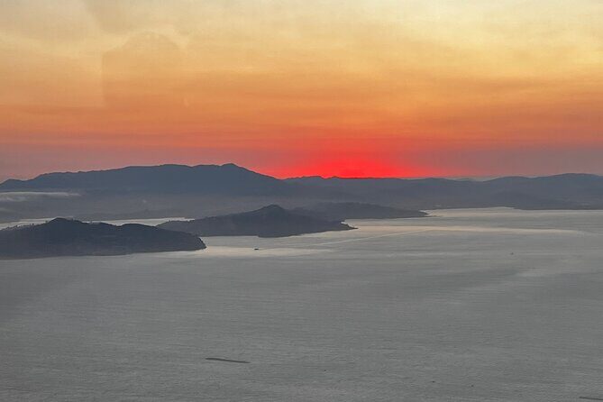
On the way back, you’ll cross over the San Mateo–Hayward Bridge area and head toward the return. This last stretch matters because it gives your eyes a final “big picture” before you land. You’ll notice how the Bay’s east side fits into the same overall picture as the west side you’ve been photographing.
Price and value: what $339 buys in the sky
At $339 per person, this isn’t the cheapest way to see San Francisco from above. But it also isn’t trying to compete with mass tours. You’re paying for a private route, a tight time window, and a pilot who can answer questions and point out landmarks as you go.
The best value angle is this: the tour hits multiple iconic areas in one flight, instead of focusing only on one bridge or one side of the Bay. People who compare this to other aerial options often point out that this approach can feel smoother and less disorienting than some helicopter-style rides, while still giving that airborne sense of scale.
If you’re traveling with a small group, the private format becomes even more sensible. The tour also requires a minimum of two people per flight, which means you’re not stuck with the “cheapest price, worst experience” problem common to some tours.
Practical tips that make this tour better
First, plan around comfort. This is a small-plane experience, so if you’re tall or you get anxious in tight spaces, it’s worth mentally preparing. One guest specifically warned that seats can feel snug for taller passengers, and that nervous flyers may want extra reassurance.
Second, bring your camera ready. The route is designed for photo angles, including major bridge passes and shoreline viewpoints. Don’t wait until you’re already over the landmark to start fumbling—get set early, because the best views can last only a few minutes at a time.
Third, pick a day with good visibility when possible. The experience requires good weather, and if it can’t run because of weather, you’ll be offered a different date or a full refund. Also, be aware that unusual airspace restrictions can affect what’s shown—especially during special events—so you might not always get every exact area on the flight path.
Finally, remember the pilot is part of the value. Guests have highlighted pilots such as Sebastian, Rick Cascelli (Chief Pilot), Rick, Matt, and Jake as being friendly and professional, with a strong focus on pointing out what you’re seeing and keeping the flight calm.
Should you book this flight tour?
Book it if you want the high-impact views of San Francisco and the East Bay without spending your whole day on transport. It’s a great choice for couples, birthdays, and anyone who likes learning while they look—especially if you want multiple big landmarks in one compact loop.
Skip it if your priority is a large, spacious aircraft feel, or if you strongly prefer only very controlled, big-airframe experiences. Also, if you’re traveling during periods when flight rules can change, keep expectations flexible for which exact areas you’ll see at the closest distance.
If you’re the type who loves photos, quick stories, and feeling like you truly understand the Bay’s geography after one flight, this is the kind of outing that usually turns into a highlight.
FAQ
How long is the airplane flight tour?
The flight is about 50 minutes to 1 hour.
What does it cost per person?
The price is $339.00 per person.
Is this tour private?
Yes. This is a private tour/activity, and only your group participates. There is a minimum of 2 people per flight.
Where does the flight start and end?
You meet at 20995 Skywest Dr, Hayward, CA 94541, USA, and the activity ends back at the meeting point.
What landmarks will we fly over?
You’ll fly over areas including Oakland, the Bay Bridge, Treasure Island, near Alcatraz, the Golden Gate Bridge, Crissy Field, the Embarcadero area, the Mission District, Twin Peaks, SFO, and the San Mateo–Hayward Bridge area on the return.
Is the tour offered in English?
Yes, it’s offered in English.
What happens if the weather is bad, and can kids or service animals participate?
The experience requires good weather. If it’s canceled due to poor weather, you’ll be offered a different date or a full refund. If you’re booking for someone under 18, they must be accompanied by an adult or the parent/guardian must sign a waiver. Service animals are allowed.